Sign up for the Family Tree Newsletter Plus, you’ll receive our 10 Essential Genealogy Research Forms PDF as a special thank you!
Get Your Free Genealogy Forms
"*" indicates required fields
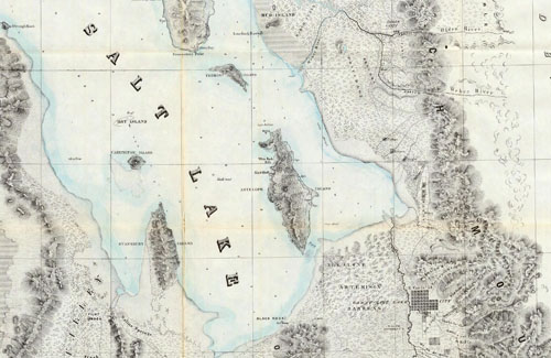
Image courtesy the David Rumsey Map Collection
In 1847, Brigham Young reportedly said “This is the place” as he gazed upon the Salt Lake Valley, feeling he had led his followers (the Church of Jesus Christ of Latter-day Saints) to their own promised land. Seeking to avoid the persecution they’d experienced in New York and Illinois, the still-young Church of Latter-day of Saints wanted to create a settlement where its members could worship freely. Young founded Salt Lake City, which was at the time outside US borders, to serve as that safe haven.
LDS independence from the United States was short-lived. After the Mexican-American War ended in 1848, the Union won a large chunk of territory out west in what would become known as the Mexican Cession—including the Great Salt Lake settlement that later became part of the Utah Territory. The Church retained some limited autonomy (Young remained governor of the new Utah territory), but the community still came into conflict with the federal government. Even still, between 1847 and the completion of the Transcontinental Railroad in 1869, more than 70,000 Mormon pioneers made the journey from Nauvoo, Illinois, to Salt Lake City along the Mormon Pioneer Overland Trail. Utah’s annual Pioneer Day celebration on July 24 commemorates these early settlers and the challenges they faced.
The map above (which the David Rumsey Map Collection calls “one of the earliest, and most important government maps of the Great Salt Lake area”) shows the Great Salt Lake and the newly settled Salt Lake City in the years following Young’s arrival. The geographic detail hints at the region’s harsh farming conditions, with numerous mountains, marshes and barrens, as well as showing the scope of the wilderness against Young’s daring settlement; the lake and surrounding wasteland is huge in comparison to the lone Great Salt Lake City (the collection of squares nestled between a river and a chain of mountains). More specifically, maps like this one (from 1852) can give you insight into the challenges your pioneer ancestors faced.
Learn more about the LDS members who traveled west on the Church’s website, which has a page dedicated to the history of the Mormon Pioneer Overland Trail. You can also use the site to search for your pioneer ancestors, or check out our guide to researching your pioneer ancestors who traveled to Salt Lake City and other westward destinations.
ADVERTISEMENT
Author