Sign up for the Family Tree Newsletter Plus, you’ll receive our 10 Essential Genealogy Research Forms PDF as a special thank you!
Get Your Free Genealogy Forms
"*" indicates required fields
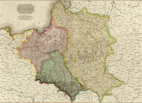
Image courtesy the David Rumsey Map Collection
Poland has had a rough history: centuries of war, deadly invasions and subjugation from foreign powers. Among the most devastating events in Polish history were the three Partitions of Poland in the late 18th century. This helpful Partitions of Poland map tells part of the story.
Poland’s neighbors Russia, Prussia and Austria first carved up Polish land in 1772. Prussia retook West Prussia (“Royal” Prussia), while Russia swept in and claimed all areas east of the Dvina and Dneiper rivers. Austria took Galicia, plus Little Poland and parts of Podolia. In 1793, Russia and Prussia finalized the second of the three Partitions: Russia seized western Ukraine and Lithuanian Belorussia, while Prussia acquired Greater Poland and part of Mazovia. The rest of Poland’s territory was annexed by its neighbors in 1795, wiping Poland from the map for 120 years.
The map above (created in 1814) shows Poland’s pre-1772 boundaries. The colored sections highlight which countries had dominion over Polish lands after the Partitions. Pink indicates Prussian holdings, green for Austrian and yellow for Russian. In addition to providing the boundaries of each partition, this detailed map also contains clues about how each partition classified the newly acquired land. For example, the Prussian partition distinguishes between East Prussia (the area along the Gulf of Dantzig), and West Prussia (the area between Prussia and East Prussia).
Knowing which partition your ancestor’s town resided in is crucial for finding records. The government ruling each partition (Prussia/Germany, Austria-Hungary and Russia) was responsible for creating and storing records. Record availability, format, coverage and even language will vary based on which country was in charge. You can find more Partitions of Poland maps on websites such as David Rumsey.
Gazetteers will help you identify the name of your ancestor’s hometown, plus how that name changed over time. FamilySearch.org has an excellent collection of Polish gazetteers. Check these out to determine which Partition your ancestor’s town became part of.
ADVERTISEMENT