Sign up for the Family Tree Newsletter Plus, you’ll receive our 10 Essential Genealogy Research Forms PDF as a special thank you!
Get Your Free Genealogy Forms
"*" indicates required fields
Comparing records and maps from similar time periods can help you confirm your map (or your record) is correct, identify individuals named in a record, and visualize the neighborhood. Here, for example, the landowner names on the 1876 map from Shade Township, Somerset County, Pa., overwhelmingly overlap with the names of heads-of-household in the 1880 US census. This confirms that the John A. Felix listed in the census is the same as the J.A. Felix on the map (and isn’t any of the other John Felixes who appear in local records).
1876 Landowner Map of Shade Township, Somerset County, Pa.
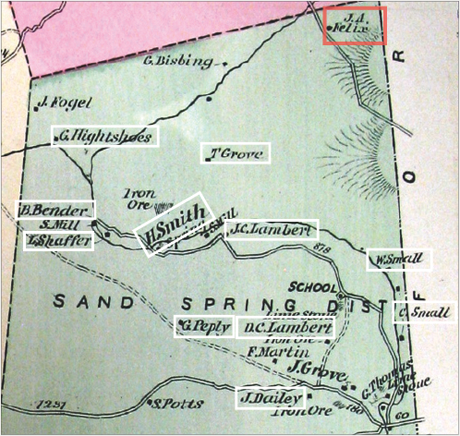
Heads of Household in the 1880 Census
- J. Daley
- G. Bebley
- David C. Lambert
- S.B. Martin
- Benjamin Bender
- Gid Heightchue
- Levi Shaffer
- H.H. Smith*
- Henry Smith*
- Hiram Lambert
- John Manges
- Joseph Lambert
- William Small
- Chancy Small
- George Beaner
- Tobias Grove
- George A. Beaner (or Bence)
- John A. Felix
* either man could be the H. Smith on the map
From the May/June 2017 Family Tree Magazine
ADVERTISEMENT