Sign up for the Family Tree Newsletter Plus, you’ll receive our 10 Essential Genealogy Research Forms PDF as a special thank you!
Get Your Free Genealogy Forms
"*" indicates required fields
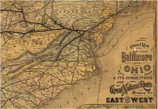
Geography and Maps Division, 98688594 (click here for a larger image)
All aboard! Railroad maps are an important resource left behind by America’s age of rail. By 1860, nearly every major city in the North and Midwest US was linked, and by the 1870s, railroads had supplanted many canals, turnpikes and steamboats. Maps display the major railways as they crisscrossed each other and surged across the country, setting the stage for railroad towns to flourish from the extra traffic.
Railway maps can give you an idea of how an area developed, showcasing where railroads (and the economic growth that followed) were headed next. They also can help you follow the paths of ancestors who worked on the railroad and those who migrated via train. Or if your ancestor hailed from a forgotten boomtown you’re struggling to find on a modern map, you might be able to pinpoint it in its heyday along a train route.
In addition to maps showing locations of tracks, railroad companies often created maps to show major lines, proposed routes, branches and stops. This map, for example, shows the Baltimore and Ohio Railroad in 1878. The Library of Congress has made more than 600 railroad maps available for free online. Many of them are high-resolution, allowing you to zoom in to your heart’s content. The FamilySearch Wiki also has entries for each of the major railroads should you happen to know which were near your ancestors.
From the January/February 2016 Family Tree Magazine
ADVERTISEMENT
Author