Sign up for the Family Tree Newsletter Plus, you’ll receive our 10 Essential Genealogy Research Forms PDF as a special thank you!
Get Your Free Genealogy Forms
"*" indicates required fields

Unlike older political entities (such as France or England), “Germany” for most of its history was a host of more-or-less independent German-speaking city-states, presenting challenges for researchers. Each German state had its own identity and cultural traditions and started keeping records at different times. Even the German language varied slightly from city-state to city-state.
From the 15th through early 19th centuries, the German states were battlegrounds in conflicts between larger, more unified nations (especially the Thirty Years’ War, which devastated many German communities). Napoleon invaded in the early 1800s, and as part of his reforms (and the Congress of Vienna that ended his reign) consolidated the several hundred German states into just a few dozen. This effectively dissolved the Holy Roman Empire and created the Confederation of the Rhine—the first political body representing a united front of German states. While the Confederation didn’t last, the idea of a united German state did; the German Empire was formed in 1871.
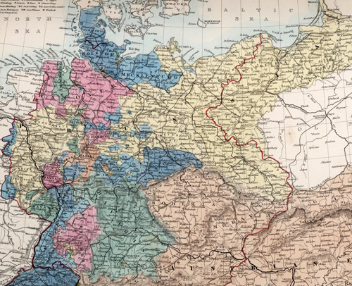
The map above, from the David Rumsey Map Collection—which has some great historical maps of individual German states—shows the area of modern Germany in 1865, just a few years before the various German kingdoms and city-states united into the German Empire. Each color represents a different city-state or kingdom, and with that in mind it’s easy to see why Prussia (which controlled a vast swath of territory across Central Europe) became the most prominent constituent member of the Empire. As you’ll notice, these states often didn’t have contiguous boundaries. Bavaria (in green), for example, contains a large swatch just west of Bohemia and a small exclave west of the Rhine, complicating research.
German researchers can take advantage of a number of resources to learn more about their ancestor’s hometown and region. The University of Wisconsin has made the useful gazetteer Des Atlas des Deutschen Reichs (Atlas of the German Empire) available online, and website Kartenmeister also has useful historical maps of Germany.
ADVERTISEMENT