Sign up for the Family Tree Newsletter Plus, you’ll receive our 10 Essential Genealogy Research Forms PDF as a special thank you!
Get Your Free Genealogy Forms
"*" indicates required fields
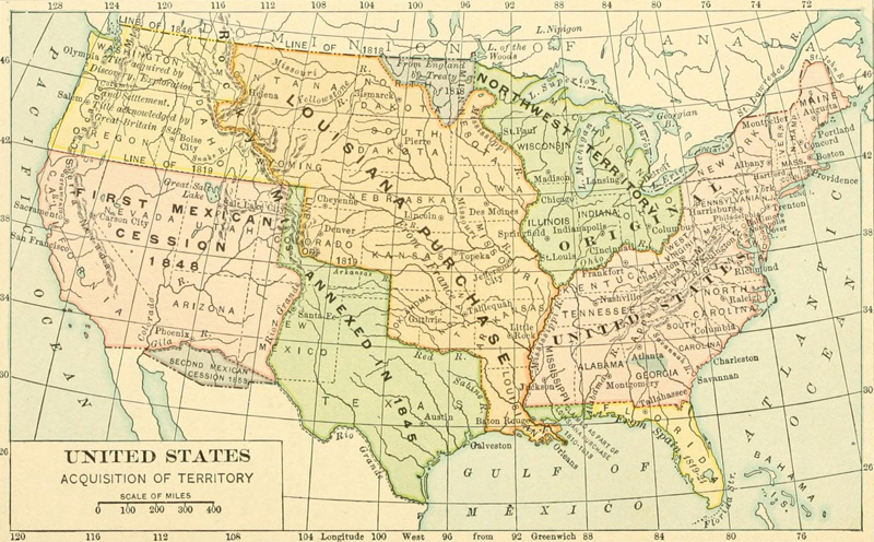
For decades, Americans flocked west to seek new opportunities. And this shift in US borders over time shows in maps, with US land increasing in leaps and bounds. (Or, perhaps, in metes and bounds!) This US expansion map displays the most important territorial acquisitions in the contiguous United States since the country’s founding. We’ll discuss each event in more detail below, based on a US territorial acquisitions timeline in the Family Tree Factbook.
The “Original” United States
The United States’ first “acquisition” came in 1783, when it secured all British land east of the Mississippi River as a condition of independence. This land included the original Thirteen Colonies, plus the Northwest Territory that would become Ohio, Indiana, Illinois, Michigan, Wisconsin and parts of Wisconsin and Iowa.
Louisiana Purchase, 1803
The French Emperor Napoleon Bonaparte sold large swaths of French territory for pennies on the acre. The land, which stretched from the Mississippi to the Continental Divide, now makes up at least part of fifteen modern states.
Treaty of 1818
After the War of 1812, Great Britain and the United States finally laid rest to a couple of long-standing territorial disputes. The agreement set the 49th parallel (seen here as the “Line of 1818”) as the boundary between United States and what would become Canada. The United States gave up claims north of this line, but gained parts of modern Minnesota and North Dakota.
Florida (The Florida Treaty, 1819)
Hoping to downsize its American holdings, Spain ceded the Florida territory to the United States. The agreement (also known as the Adams-Onís Treaty after each country’s representative) also defined the boundary between the United States and New Spain. This boundary formally recognized US ownership of southern Mississippi, Alabama and Louisiana. It also created borders in the Oregon territory and in what would become Texas. (Though these boundaries were somewhat short-lived; see the next two events.)
The Annexation of Texas, 1845
“New Spain” (Mexico) gained independence from Spain in 1821. But the Mexican Empire soon faced rebellion along its northeastern border. During the 1830s, American-born pioneers living in modern Texas successfully fought for independence from Mexico. Not long after, the fledgling Republic of Texas voted to join the United States.
Oregon (The Oregon Treaty, 1846)
The United States and Great Britain long squibbled over who owned the sought-after Oregon country. As we discussed, the United States and Spain set Oregon’s southern boundaries in 1819. But ownership of some parts of the region remained an open question. And with thousands of American migrating to the region along the Oregon Trail, Oregon’s fate became a hot political issue. Finally, Great Britain recognized US ownership of the area in 1846, once again setting the 49th parallel as the boundary between the two countries’ holding. In exchange, Great Britain retained the land north of the line (modern British Columbia).
The First Mexican Cession, 1848
The United States started—and won—its own war against Mexico not long after annexing the Republic Texas, itself former Mexican territory. In the Treaty of Guadalupe Hidalgo, Mexico turned over more than 525,000 square miles of land in what is now the American West. Check out this map of western territories to determine how this new land became US states.
The Second Mexican Cession, 1853
Better known as the Gadsden Purchase, this transaction turned modern southern Arizona and southwest New Mexico over to the United States. The two countries hoped to smother smoldering resentments left by the Mexican-American War. And (perhaps more importantly) the United States needed the land to complete a southern leg of the transcontinental railroad.
This map appears in the Family Tree Factbook, a new quick-reference book full of important genealogical dates and statistics. Inside, you’ll find historical timelines, definitions and maps that will help you trace your ancestors bask in time. In addition, the book features strategies for researching your family tree in census and land records, as well as genealogy websites.
ADVERTISEMENT
Author


_(14796705723).jpg)