Sign up for the Family Tree Newsletter Plus, you’ll receive our 10 Essential Genealogy Research Forms PDF as a special thank you!
Get Your Free Genealogy Forms
"*" indicates required fields
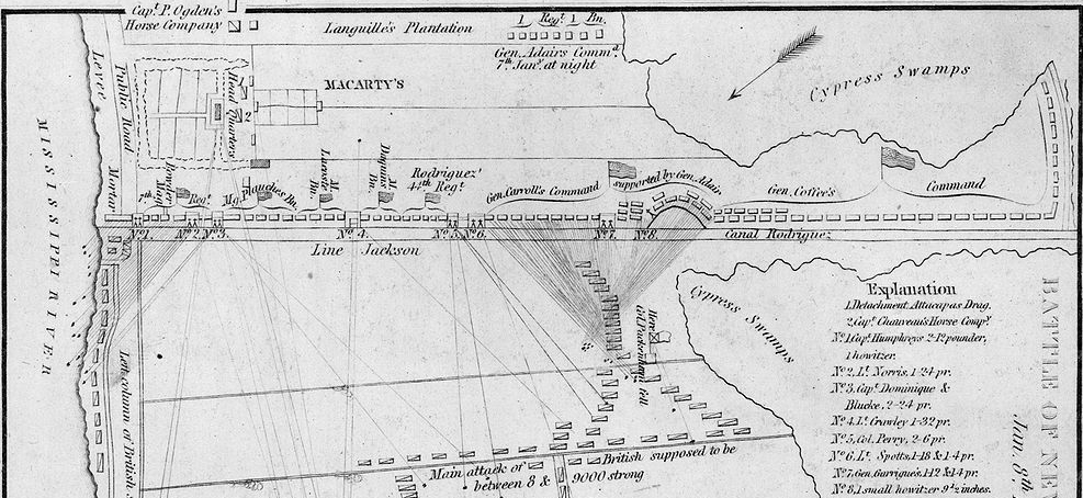
A month-long chess match with the British, pirates, a forgetful lieutenant colonel, and an upstart general earning his stripes as a national hero. The Battle of New Orleans had no shortage of drama. This Battle of New Orleans map helps tell the story of a pivotal moment in the War of 1812.
In late December 1814, American forces under General Andrew Jackson dug in to defend New Orleans. Jackson failed to rout the British in December, but successfully repulsed a British attack on New Year’s Day. Greatly outnumbered by the encroaching British forces, Jackson ordered his men to construct a line of defense along the Rodriquez Canal, which ran from the Mississippi River to a nearby swamp.
Most men on the line didn’t have formal military experience. In fact, many of them were sharpshooting frontiersmen from Kentucky and Tennessee, free blacks and volunteers from New Orleans. Jackson even enlisted the help of local pirates to defend the city. This so-called “Line Jackson” proved pivotal, harboring heavy artillery and long-range marksmen.
The British under General Edward Pakenham advanced on January 8, 1815. However, their attack quickly and spectacularly fell apart. The advance took longer than expected, and the rising sun and breaking fog left the British out in the open. In addition, Lt. Col. Thomas Mullins forgot to bring along the equipment needed for the British to cross the 15-foot-wide Rodriguez Canal. By the time Mullins realized his mistake, American artillery had killed hundreds of British troops who had nowhere to go, including Pakenham. The British lost 2,000 men in less than half an hour, and Mullins was court-martialed.
Perhaps the most surprising element of the Battle of New Orleans was its timeliness. The United States and Britain reached a ceasefire on Christmas Eve, 1814, but the news had not yet reached either Jackson or the British commanders. Tactically, the battle didn’t matter, as the war had already ended. But Jackson received nationwide acclaim for his plucky defense of New Orleans, and the victory boosted American morale. This glory later bolstered him to the White House, where he served as president from 1829 to 1837.
The map showcases several key factors in the battle. We can see how Line Jackson stretches along “Canal Rodriguez,” and the Explanation notes the various artillery units bolstered there. The map even marks where Pakenham was killed. The lines extending from American defenses to the British forces likely indicate lines of fire, showing just how vulnerable the British were to American artillery.
The Library of Congress holds several great military maps, including this one. You can use these maps to learn about your ancestors who served in the battle or lived in New Orleans at the time. Check out this article to learn about great War of 1812 research websites.
Those of you with ancestors who served in the War of 1812 can also check out the Preserve the Pensions project. This volunteer effort works to index the National Archives’ massive collection of pension records from this oft-forgotten war. Researchers can access the records and indexes for free, or you can sign up to help index records. The project has the support of big names such as the Federation of Genealogical Societies and Ancestry.com/Fold3.
ADVERTISEMENT
Author