Sign up for the Family Tree Newsletter Plus, you’ll receive our 10 Essential Genealogy Research Forms PDF as a special thank you!
Get Your Free Genealogy Forms
"*" indicates required fields
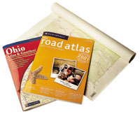
Rand McNally 2001 Road Atlas: United States, Canada, Mexico
A genealogist needs maps showing small towns, roads and county names and boundaries. This inexpensive road atlas fits the bill and also includes an index to counties, cities and towns. Unfortunately, the Canadian maps do not show county names and boundaries. $8.99. www.randmcnally.com, (800) 275-7263
DeLorme Atlas and Gazetteer Series
Each state atlas in this series features maps drawn at a scale of about 3 miles per inch, each covering roughly 25×40 miles. The maps show towns, townships, roads and physical features. $19.95 each. www.delorme.com/atlases
US Geological Survey Maps
A detailed map can help you see the contour of the land where your ancestors lived and help you identify nearby churches and cemeteries. USGS topographic maps drawn at a scale of 1 inch equals 2,000 feet show roads, trails, rivers, lakes, buildings and political boundaries. The maps are typically about 20×28 inches and show a 7×10-mile area. Go to mapping.usgs.gov and choose Map Lists or MapFinder for topographic maps. $4, plus $5 handling. (888) ASK-USGS
Find more map options, including sources for old maps, in the August 2001 Family Tree Magazine.)
ADVERTISEMENT