Sign up for the Family Tree Newsletter Plus, you’ll receive our 10 Essential Genealogy Research Forms PDF as a special thank you!
Get Your Free Genealogy Forms
"*" indicates required fields
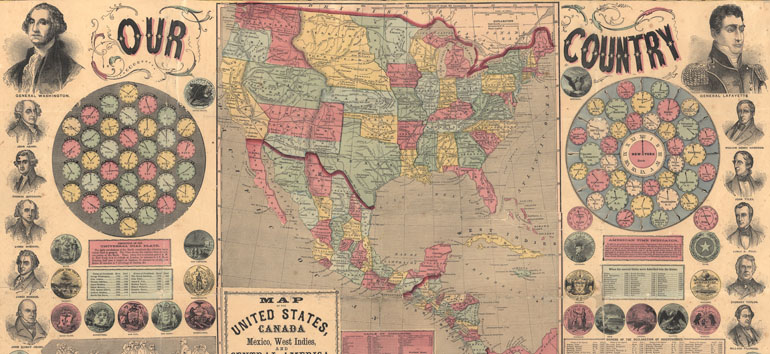
All maps have educational value, but some teach you more about history than others. This 1859 map doubles as a social studies lesson. Let’s take a look at this information-packed historical map of the United States.
The map itself serves as a snapshot of the country just two years before being plunged into civil war. Southern states haven’t yet seceded, and West Virginia is still part of Virginia. The map also helpfully shows Mexico and Central America, plus the statuses of the various Western and Midwestern US territories. (Learn more about how the West was settled.)
Scattered throughout the map, you’ll also find each state’s seal, plus a table indicating when each state joined the Union. At the time, Oregon wore the “newest state” crown, gaining admission to the Union in February 1859. The table lists Utah, Kansas and Nebraska even though these territories hadn’t yet gained statehood.
In addition, the map has other info that can help you trace the country’s history and development. Along the image’s borders, you’ll see portraits of each US president from George Washington to James Buchanan, plus other Revolutionary figures like the Marquis de Lafayette and Ben Franklin. A table indicates birth and (when appropriate) death dates for each president. As you might expect, the two most recent former presidents (Millard Fillmore and Franklin Pierce) still lived in 1859. But Martin Van Buren (in office 1837–1841) was the earliest former president still alive. Van Buren and John Tyler (in office 1841–1845) both died a few years later in 1862.
This map also contains useful information about the country’s founding. At the bottom (which you can see by viewing the complete image), you’ll see a reproduction of John Trumbull’s famous Declaration of Independence. A labeled diagram above the painting indicates the identities of each of the painting’s subjects, and (to the right) a table lists the 56 signers of the Declaration of Independence, plus home states and death dates for each.
Interestingly, the map also features times for various cities, both in the United States and abroad. Before the United States hasn’t always had universal time. Before 1918, the United State didn’t have a standard time or uniform time zones. Rather, each locale kept its own time based on the position of the sun in the sky, leading to travel and logistical headaches.
Want to learn more about old maps? Check out our Historical Maps Cheat Sheet, which will show you how to find and use a variety of historical maps in your research. You can also check out The Family Tree Historical Maps Book for more interesting historical maps of the United States.
ADVERTISEMENT
Author