Sign up for the Family Tree Newsletter Plus, you’ll receive our 10 Essential Genealogy Research Forms PDF as a special thank you!
Get Your Free Genealogy Forms
"*" indicates required fields
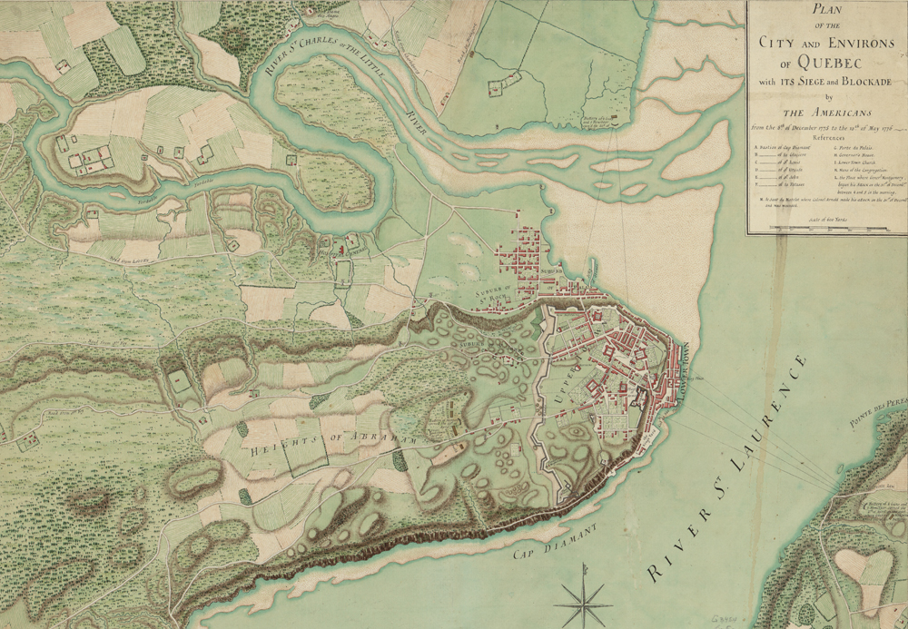
You might not think of Canada as an important battle site in the Revolutionary War, but the fighting reached all the way up to the Quebec province. This historical map of Quebec city, created in 1776, shows the site of a decisive battle in the short-lived Canadian campaign of the Revolutionary War.
The Americans had high hopes for capturing British Canada, and early successes emboldened them. On Nov. 13, 1775, General Richard Montgomery and his army captured Montreal without firing a single shot. Caught flat-footed after quashing an attack by Ethan Allen and his Green Mountain Boys, the British had to surrender.
Ultimately, though, the American invasion failed. Forces under Gen. Montgomery joined Benedict Arnold (then a major-general in the Continental Army), and the two attacked Quebec in late December. The British shot Montgomery off his horse, killing him and routing his army. The Americans maintained a blockade of the city over the next several months, but they had to abandon the campaign.
The map above shows Quebec city in the months during and following the Americans’ defeat in Quebec. The map shows remarkable detail, including each building as well as shading that represents topography. Letters indicate various military strongholds, and the L (on the eastern shore, near the label for Cap Diamant) marks where Gen. Montgomery and his men began their (failed) assault.
In addition to its wartime importance, this map hints at the sociocultural forces at work in Quebec. Though (Protestant) England had taken over Canada in the 1760s, the Catholic Church remained highly influential among the French-speaking population. You can see this influence in how the town is laid out, with a “Bishop’s Palace,” buildings for the Jesuits and Ursulines (two Catholic religious orders) and a cathedral. This tension between Canada’s competing English-Protestant and French-Catholic influences remains even today.
This map comes from the Library of Congress, where you can find many great documents from the Revolutionary War. Those interested in Canadian genealogy should also check out the Library and Archives Canada’s website’s collection of historical maps of Quebec and other provinces.
ADVERTISEMENT