Sign up for the Family Tree Newsletter Plus, you’ll receive our 10 Essential Genealogy Research Forms PDF as a special thank you!
Get Your Free Genealogy Forms
"*" indicates required fields
Mountains, valleys and rivers shaped not just the landscape of your ancestral hometown, but also your ancestors’ lives. Geography can give you clues about how your ancestors lived and made decisions: Why did your third-great-grandmother settle on the west side of a river’s bend instead of the east? Did your great-uncle really trudge uphill both ways to get to school?
Traditional maps are great for showing political boundaries and waterways, but these two-dimensional resources may fail to capture other geographic barriers that affected your ancestors’ decisions on where to live.
Topographical maps attempt to flatten the three-dimensional landscape by using contour lines to indicate elevation. Each contour traces geographical features of the same elevation, giving you a sense of changes in the area’s landscape. Lines that are close together represent rapid changes in elevation, such as a steep mountain.
This type of obstacle may have caused your ancestor to travel to the adjacent county’s seat of government for legal business, or forced migrants to find an alternate route. Lines spaced farther apart indicate gradual changes, such as a rolling hill or a farmer-friendly prairie.
The US Geological Survey (USGS) has produced topographical maps since 1879 and maintains an online tool that overlays historical topographical maps onto modern political maps. Search for a location, then click the place name. Select a historical map from the timeline at the bottom, and adjust the transparency to view it over a modern map.
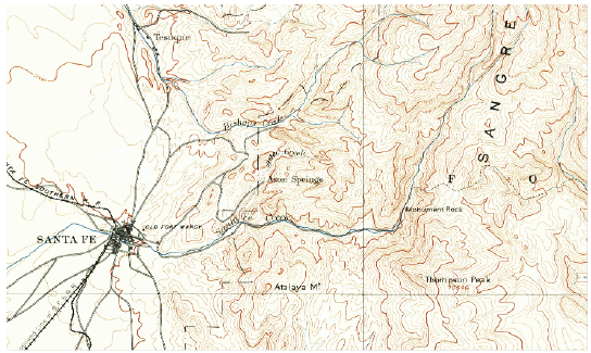
This 1889 topographical map, for example, shows eastern Santa Fe in pre-statehood New Mexico. The brown lines indicate elevation (in feet). Close contour lines to the east indicate the Sangre de Cristo Mountains. It’s possible inhabitants first settled in the West because the terrain was less tumultuous than it was in the East.
By consulting topographic maps, you can gain similar insights into your own ancestors’ surroundings.
From the October/November 2015 issue of Family Tree Magazine
ADVERTISEMENT
Author