Sign up for the Family Tree Newsletter Plus, you’ll receive our 10 Essential Genealogy Research Forms PDF as a special thank you!
Get Your Free Genealogy Forms
"*" indicates required fields
It’s easier than ever to put your US ancestors on the map, thanks to the new TopoView website from the US Geological Survey (USGS). Its powerful tools help you find your ancestral stomping grounds among 178,000 topographic maps dating from 1884 to 2006 and scaled to 1:250,000 (an inch on the map represents 250,000 inches on the ground) and more detailed.
You can pan across old maps, zoom in and out, or shift-click to select any rectangular part of the map. (Tablet users can pinch and zoom.) A double slider lets you narrow the date range, while a box offers five scale options, from 1:250,000 to 1:24,000 (or “Show All”). You can enter a location or click the My Location icon to center and zoom in on your current location. One click lets you view a map online or download it as a PDF, JPEG, TIFF or KMZ (importable into Google Earth) file.
Colors that match the scale options indicate available maps for each location. Clicking a colored square brings up details about that map; the pointer icon in the box that appears summons a list of all maps for this spot. Here’s how I used TopoView to find maps of Pottsville, Pa., birthplace of my wife’s 19th-century ancestor Elizabeth Bradbury:
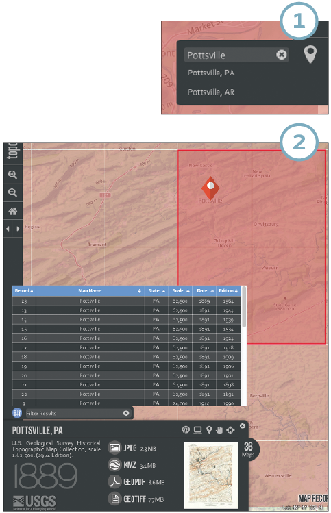
1. TopoView opens to a US map.
I typed Pottsville in the location search box at the upper right. The site found two, in Pennsylvania and Arkansas.
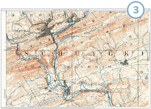
2. Selecting the Pennsylvania Pottsville added a red diamond on the map at the town’s location.
Clicking the diamond brought up a box with info about the selected map; the pointer icon then produced a list of other available maps. Clicking any of the headers on this list—Map Name, State, Scale, Date, Edition (for reprinted maps)—sorts by that field. I clicked the Date header to locate the oldest map, from 1889. Selecting that map redrew the main map to show (in red-orange) the area covered by that 1:62,500-scale map. (The hand icon pans to center this area, while the diamond-X icon zooms to show just the selected map area.)
[[preview]]
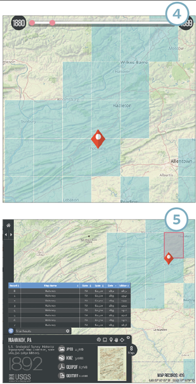
3. I could download the 1889 map by clicking my preferred file format, but first I wanted to see what I’d get.
I clicked on the miniature map preview to bring up a high-resolution, zoomable window right in my browser. I could click to zoom in on this image, or scroll around to see more. Now I could understand the proximity of Pottsville to other places in the Bradbury family tree, as well as spot nearby locales that might be worth investigating for records.
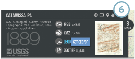
4. Next I zoomed out to view more of that chunk of Pennsylvania.
I used the timeline sliders to show only maps before 1900. (Both ends of the slider move, so you can select a range such as 1895 to 1925.) Blue boxes indicated maps available at about 1:62,000 scale; areas shown only in the green and yellowgeneral topographic map colors didn’t have coverage for my selected timespan.
5. Pottsville is close to the north end of the map I viewed…
So I clicked on the blue box just above the Pottsville marker and found another useful map, showing Mahoney, Pa., about the same time. I also checked the area to the northwest of Pottsville, labeled Catawissa, which was represented by 1892 and 1889 maps.
6. I downloaded all three maps in the GeoPDF file format
Which I can open with the free Adobe Reader.
ADVERTISEMENT