Sign up for the Family Tree Newsletter Plus, you’ll receive our 10 Essential Genealogy Research Forms PDF as a special thank you!
Get Your Free Genealogy Forms
"*" indicates required fields
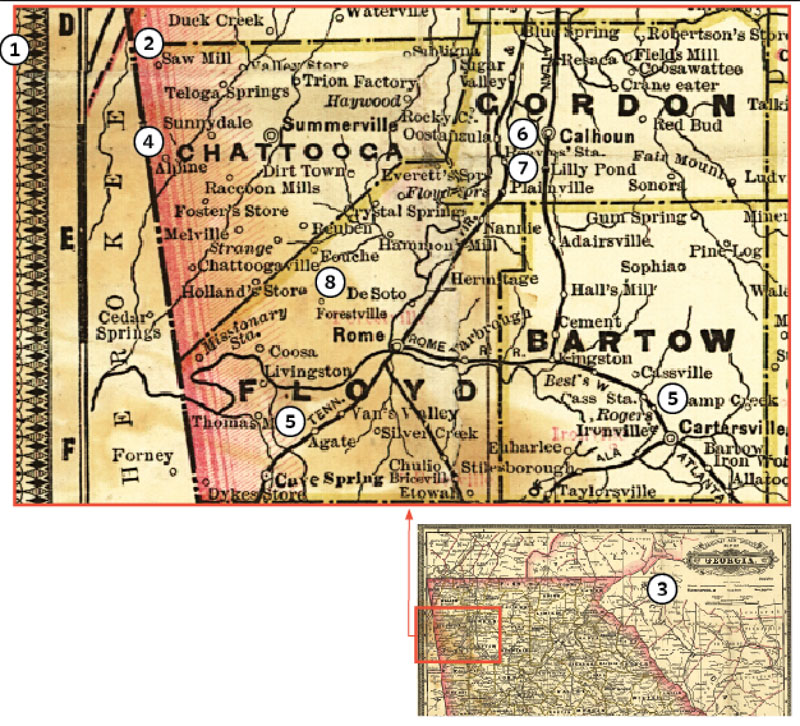
1. Vintage railroad maps, like this 1883 one of Georgia, show rail lines, routes, stations and stops. Use them to trace your ancestor’s potential migration paths, learn about working on the railroad, and see the places your family lived.
2. Some stops, such as Saw Mill, Valley Store and Foster’s Store, aren’t towns, but instead may be businesses acting as post offices or freight depots.
3. A legend and scale, either on the map or elsewhere in an atlas, explains markings. Some maps note rivers and other bodies of water as landmarks.
4. This map prominently displays county names and boundaries. Major cities are bold.
5. Bold lines indicate railroads, with the name of the line alongside. Follow the rail line and note name changes. The Tennessee and Virginia runs southwest to northeast through Rome, Georgia; the Rome railroad becomes the Atlanta at Cartersville. Use the names to learn about the line and look for personnel records.
6. Open circles enclosing dots along the rail line denote major stations with ticket offices.
7. Open circles along the line mark minor stops, often made only on passenger request.
8. Maps also show other populated places, where proximity to the railroad provided access to transportation and deliveries.
For more on using historical maps, check out our roundup of the seven most useful maps for genealogy and our collection of how-to’s for using maps of all shapes and sizes.
A version of this article originally appeared in the January/February 2019 issue of Family Tree Magazine.
ADVERTISEMENT