Sign up for the Family Tree Newsletter Plus, you’ll receive our 10 Essential Genealogy Research Forms PDF as a special thank you!
Get Your Free Genealogy Forms
"*" indicates required fields
Picasso never painted a map, but hand-drawn historical charts of geographic areas are pieces of art in their own right, as well as genealogical references. The digitized Panoramic Maps Collection on the Library of Congress website contains nearly 1,500 beautifully sketched bird’s-eye views of US cities and towns during the 19th and early 20th centuries.
Also known as perspective maps or aero views, these non-photographic representations show cities from an oblique angle, effectively depicting urban development spread across the landscape.
Even though cartographers rarely drew panoramic maps to scale, they’re still useful research tools. By studying a perspective map of your ancestor’s hometown, you can identify genealogically significant buildings such as churches and courthouses, discover old street patterns and observe noteworthy features, such as parks or canals.
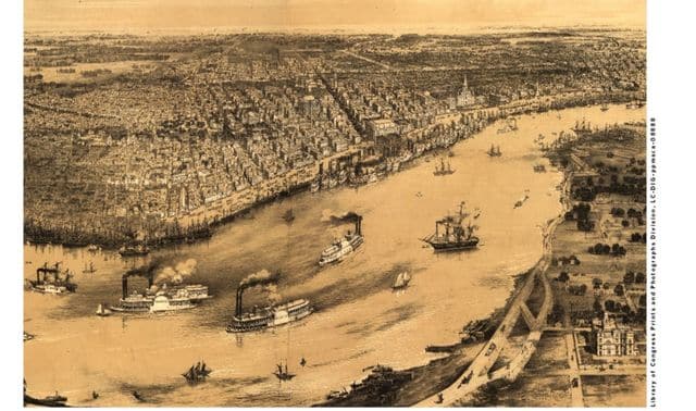
This panoramic map shows New Orleans in 1851, drawn by artist John Bachmann. The map is positioned so viewers are looking north over the French Quarter and Central Business District from across the Mississippi River, with the 15th Ward, Algiers, in the foreground. The iconic St. Louis Cathedral can be seen along the river on the right, towering above neighboring structures.
The map also illustrates the sheer volume of ships that would’ve passed through the Port of New Orleans in the 1850s. In 1862, 11 years after this map was drawn, Union forces captured the port during the Civil War, cutting off a primary source of supplies for the Confederate Army.
From the September 2015 Family Tree Magazine
ADVERTISEMENT