Sign up for the Family Tree Newsletter Plus, you’ll receive our 10 Essential Genealogy Research Forms PDF as a special thank you!
Get Your Free Genealogy Forms
"*" indicates required fields
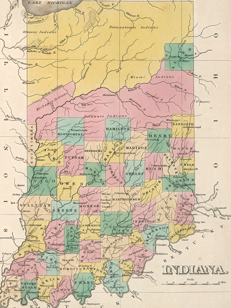
Indiana doesn’t look so bad for 201 years old! The state was founded on Dec. 11, 1816. This historical map of Indiana from 1827 hints at the state’s history of land purchase and conflict with Native Americans. The map displays Indiana 11 years after it achieved statehood. Lawmakers had founded Indianapolis, the state’s capital, just a few years earlier. Notice the large swaths of land in the northern part of the state, much of which still belonged to Native American tribes.
European and American settlers long clashed with Native Americans in Indiana (whose name literally means “Land of the Indians”). William Henry Harrison, the first governor of the Indiana Territory, negotiated several land treaties with the Native Americans in the early 1800s. Not all tribes agreed to the terms, however, and some began to revolt. Tensions bubbled over in the Battle of Tippecanoe in 1811, where Harrison defeated a Native American confederacy led by Shawnee warrior Tecumseh. Ongoing skirmishes between settlers and Native Americans continued during the War of 1812, in which many tribes sided with the British. The Treaty of Ghent at the war’s end effectively ceased armed conflict between settlers and Native Americans in Indiana.
By the time the state was founded in 1816, settlers and Native American tribes had reached an uneasy peace. The US government continued to negotiate with the tribes, expanding Indiana for American settlement. The largest, the Treaty of St. Mary’s in 1818, ceded huge tracts of central Indiana to the United States.
According to the map, the Miami, Delaware and Kickapoo tribes still populated the pink region in central-northern Indiana in 1827. Likewise, the Potawatomi (or Pottowatomie) and Ottaway owned the yellow strip. All five tribes surrendered most of their land to the US government through a series of treaties within the next decade. In addition to buying off their land, the government also forcibly relocated hundreds of Potawatomi in 1838.
This map comes from the David Rumsey Map Collection, which contains thousands of free online maps. You can also discover more historical maps of US states in The Family Tree Historical Maps Book, an atlas of US states and territories from 1790 to 1900.
ADVERTISEMENT