Sign up for the Family Tree Newsletter Plus, you’ll receive our 10 Essential Genealogy Research Forms PDF as a special thank you!
Get Your Free Genealogy Forms
"*" indicates required fields
There are so many layers to a photo identification and interpretation problem. A family photograph is a lot more than just figuring out who’s in the image. Each photo tells a story.
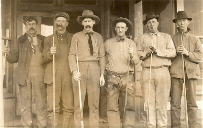
This image of billiard players outside a Mulhall, Okla., pool hall appeared in last week’s Photo Detective Blog post, and in the in the May/June issue of Family Tree Magazine.
In the magazine, I explored occupational clues in their attire. In the blog post, clues in the picture led to a possible identification based on the rivets in one man’s chaps.
This week it’s pinpointing the location of the billiard hall.
Using the Sanborn Insurance Maps, a ProQuest database that’s available through many libraries, I was able to locate where these men stood.
Sanborn Insurance Maps are a wonderful resource for anyone looking for more information on a particular building. You can view the building in context of its surroundings, learn about details in the structure such as the location of staircases, elevators and how larger businesses were heated. Sometimes there is information on the type of building material. Often, the maps tell you what types of businesses operated in a building and sometimes with a specific business name. (Learn more about Sanborn maps and see an example here.)
These maps are very useful when city directories aren’t available for an area or when used in conjunction with city directory information. The digital Sanborn collection covers the years 1867 to 1970. It’s not comprehensive for every city/town or even every block.
There are several maps for Mulhall in the collection, so narrowing the time frame was the first step.
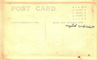
The style of the stamp box, combined with the divided design on the back of this photo postcard, dates this card to after 1907. On March 1, 1907, it became legal to include both the address and a message on the back of a postcard.
The August 1908 Sanborn Map for Mulhall shows that a billiard hall operated at 57 Baty Street.
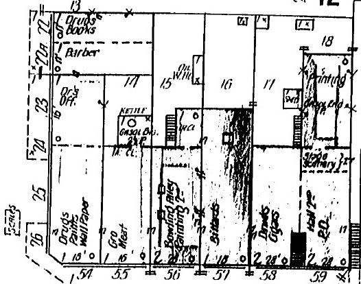
According to the 1910 US census, Yeve J. Cox operated a pool hall in town. This map doesn’t list the name of the pool hall’s owner. It’s possible that Cox appears in the photo above.
There was a surprise on the October 1915 map of the town: The billiard hall was gone, replaced by a moving pictures establishment. At 62-1/2 Baty Street was a photographer’s studio. According to Kathryn Stansbury’s History of Mulhall, Oklahoma: 100 Yesteryears (Transcript Press, 1988), a Cunningham’s pool hall burned down in 1919. It’s unclear if both establishments were the same business.
This information suggests that the photograph was taken between 1907 and 1915. Given what’s known about the men in the picture, it’s likely closer to 1907.
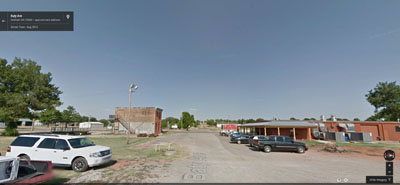
A lot has changed in Mulhall since these men posed for this portrait. Google Maps shows how many of the buildings on Baty are now gone.
Using a combination of historical maps and modern technology brings a new layer of interpretation to Charlotte Flock’s family photo.
Solve your family photo mysteries with these books by Maureen A. Taylor:
ADVERTISEMENT