Sign up for the Family Tree Newsletter Plus, you’ll receive our 10 Essential Genealogy Research Forms PDF as a special thank you!
Get Your Free Genealogy Forms
"*" indicates required fields
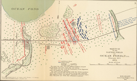
Image courtesy David Rumsey Map Collection
In 2017, the Alabama Crimson Tide and the Clemson Tigers competed in Tampa to crown the college football national champion, but the two southern schools weren’t the only foes to face off in Florida. Back in February 1864, Union and Confederate forces squared off near Jacksonville in the little-remembered Battle of Olustee (or Battle of Ocean Pond), the only major Civil War battle on Floridian soil. Much bloodier than a football game, the Battle of Olustee was a victory for the South that (temporarily) halted Union excursions into the Sunshine State.
The map above, made by the Confederate Army and digitized by David Rumsey, depicts each side’s positions throughout the conflict. Confederate forces are in red, and Union forces (labeled the Enemy) are in blue. As the map’s notes suggest, the Confederate Army repelled advancing Union forces who were trying to take Lake City, forcing General Truman A. Seymour and his men to retreat to Jacksonville. The Union suffered more than 1,800 casualties out of its 5,500 men, making the Battle of Ocean Pond one of the bloodiest battles of the Civil War when looking at the ratio of casualties to the number of combatants. Historians perform a reenactment of the battle each year in commemoration.
The map provides useful details for researchers who have Civil War ancestors or ancestors in the Jacksonville area. Here, you can see specific Confederate regiment numbers, as well as strategically useful roads (the Lake City and Jacksonville Road), railroads (the Olustee Station and the Florida, Atlantic, and Gulf Railroad), landmarks (“Old house used as hospital”) and geographic features (various “impracticable” bays and other waterways). This particular depiction comes from a larger volume of maps, each providing a different significant Civil War site that may be of interest to your research.
ADVERTISEMENT